Categories
Trips

Monument Valley, Four Corners, Antelope Canyon

Долина монументов. Четыре угла. 

В начале апреля туристов не очень много. Некоторые тропы ещё завалены снегом. Но нам хватило и того, что посчастливилось увидеть. Я думаю, для путешествия выбрано правильное время. 

А мы едем дальше. Горы вокруг нас становятся ниже, а в долинах — жарче. Уже сняты куртки и шапки, которые нужны были ещё утром.  Из ботинок переобуваемся в кроссовки. Перед нами, необычные рельефы — Долина монументов( Monument valley).  

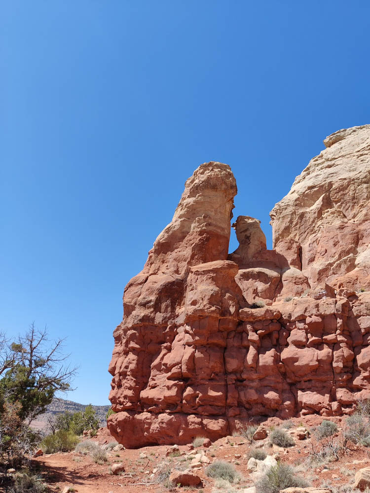
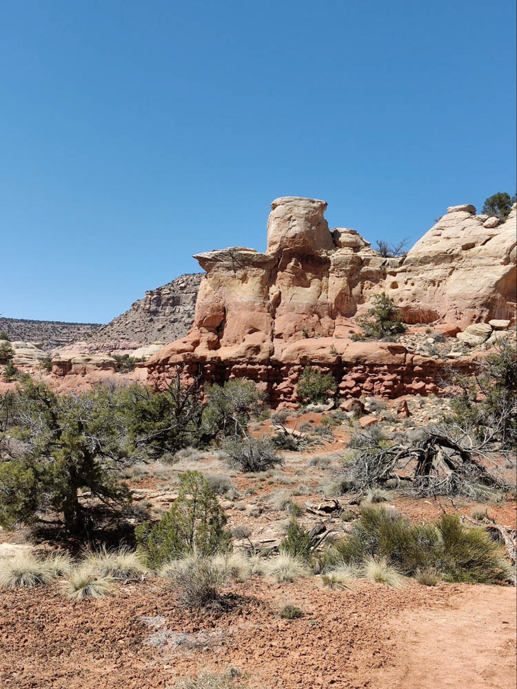
Мы проезжали в этих краях лет десять назад. Но это такие большие территории, что за один раз всего не увидишь. И в этот раз мы смогли посмотреть лишь небольшой кусочек.  Долина монументов — это  остатки, обмылки гор, которые приняли самые причудливые формы стараниями ветра, воды и времени.  Например, едешь — и вдруг среди долины ровныя скульптурная группа » Люди в шляпах».  Но чаще без шляп. Высотой метров триста.  Или какой-нибудь одинокий перст такого же роста.

  В этот раз мы выбрали только одну тропу, что лежала ближе всего к нашему маршруту —  Walnut canyon. После зимних температур, организм не был подготовлен к такому стремительному потеплению. Вот ещё пару дней назад мела пурга и мёрзли руки, а теперь + 25°С . Такое ощущение, что здесь стоит ужасная жара.

Но контрасты бодрят и держат в тонусе, а перемена декораций подстёгивает любопытство. 

 Мы подключили фантазию и стали придумывать на что похожи скалы.

Больше всего — на плохо слепленных глиняных человечков. 

Снова встретились руины пуэбло, но не такие живописные, как в предыдущем парке. После обеда едем дальше. 

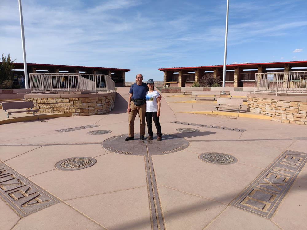
Следующая наша остановка — интересная географическая точка. Она называется » Четыре угла».

Здесь сходятся вместе четыре штата: Аризона, Нью-Мексико, Юта и Колорадо. Люди фотографируются на корточках, поставив руки и ноги в разные штаты. Индейцы Навахо, которым принадлежат эти территории, продают здесь изделия ручной работы: ювелирные украшения, керамику, декоративные ножи и стрелы. Мы решаем в качестве сувенира купить расписной деревянный шар на новогоднюю ёлку. 

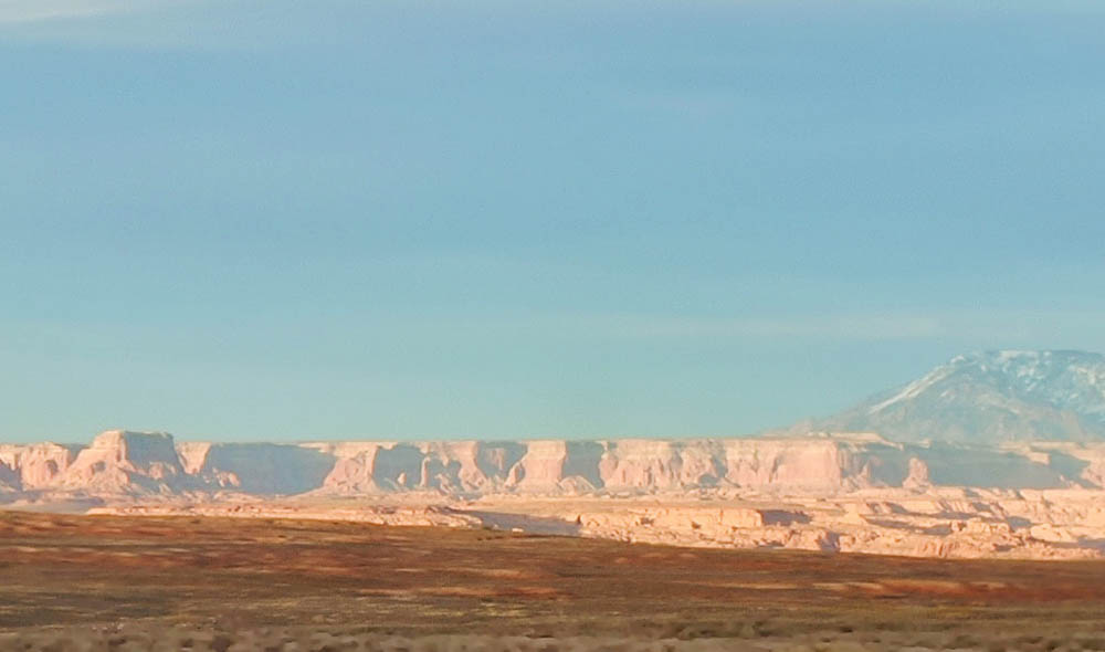
Плоскогорья, вдоль которых мы едем в город Page, под вечер окрашиваются в приятные пастельные тона: розовые, персиковые и сиреневые.

Уже в сумерках подъезжаем к гостинице. По-быстрому в душ, а потом ужинать в мексиканский ресторан. Таков был план: из дикости — в цивилизацию и обратно. Как оказалось, подобный полукочевой образ жизни ведём не только мы. Люди едут, кто на легковых машинах, чаще на внедорожниках, кто на RV разных конфигураций. Дороги хорошие и бизнес в этих краях заточен на всяческую поддержку автомобильного туризма. Замечено  также, что путешествуют, в основном, люди немолодые, у которых выросли дети, имеются деньги, и не обременяет работа. Вот и мы оказались среди них.

Каньон Антилопа

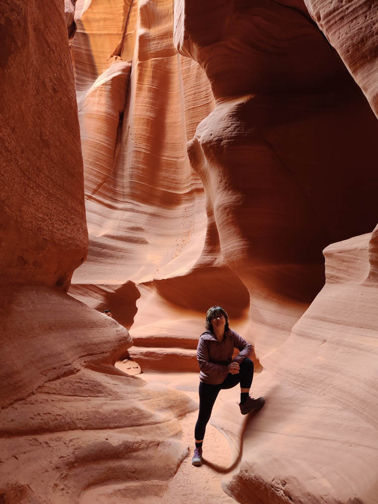
По каньону Антилопа нельзя прогуляться просто так. Нужно обязательно купить тур с гидом. Резервировать тур лучше  заранее, потому что место очень популярное. Владеют бизнесом всё те же  индейцы Навахо. Думаю они получают неплохую прибыль.  Наш гид был как раз одним из них, молодой парень по имени Марко. 

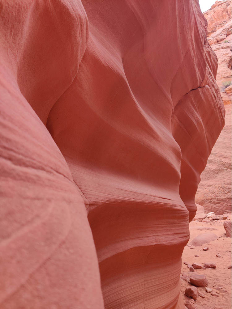
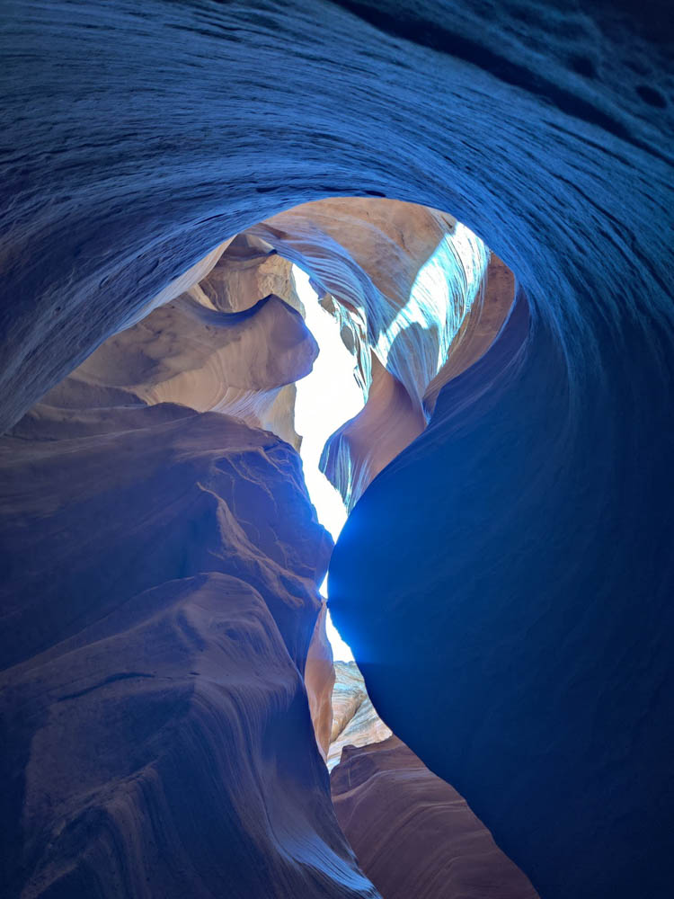
Каньон Антилопа не слишком глубокий, но сказочно красивый.

В сезон дождей он становится опасен: его узкие проходы наполняет  вода, которая бурным потоком несётся по расщелинам. И так — веками. От этого все углы и впадины  сглажены. Там нет острых камней, но есть волнистый вертикальный рельеф, глядя на который снизу вверх, приходишь в изумление от этой нерукотворной красоты. 

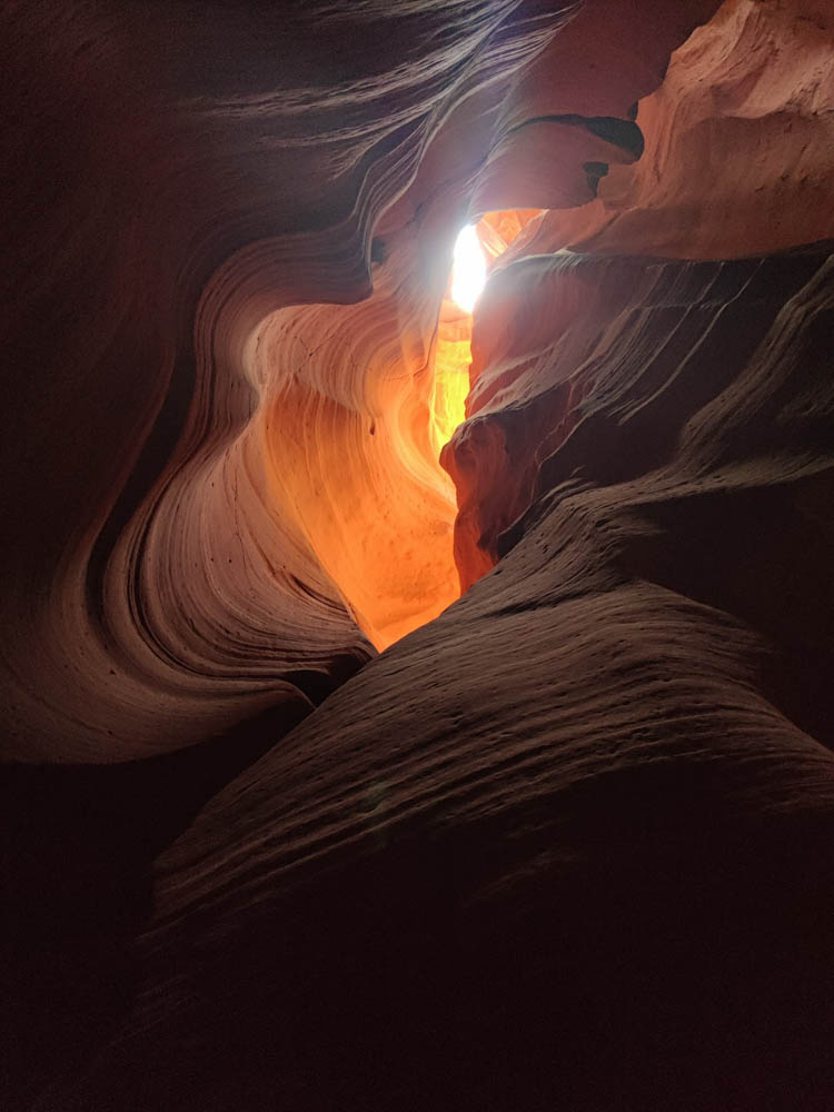
Я сделала много фотографий, а удалить смогла лишь несколько. Остальные выкидывать просто  жалко — настолько удивителен мир каньона Антилопа. 

Длина его ходов 24 мили. А увидеть можно лишь небольшую часть. Я расспрашивала гида с пристрастием, так ли прекрасен каньон на всем его протяжении? А Марко отвечал, да, но в какой то момент  становится шире.

Я повидала немало чудес, но сюда  хочется вернуться ещё раз.

Спустя некоторое время подъезжаем к реке Колорадо, а точнее к историческому мосту — Navajo Bridge. Мост был построен в 1929-м, до этого люди пользовались паромом. Однако в 1928-м году произошел несчастный случай и паром затонул. Новый решили не запускать, потому что уже строился мост, да и объезд не такой уж большой — всего 800 миль 😀.

Я уговариваю заехать Дениса в Vermilion Cliffs National Monument, но он не соглашается, аргументируя, что это слишком большой крюк. Ну что ж, едем по намеченному маршруту в сторону Grand Canyon.

Про наш спуск на дно Гранд Каньона хорошо написал Денис. Я лишь добавлю несколько слов о том, что меня удивило.

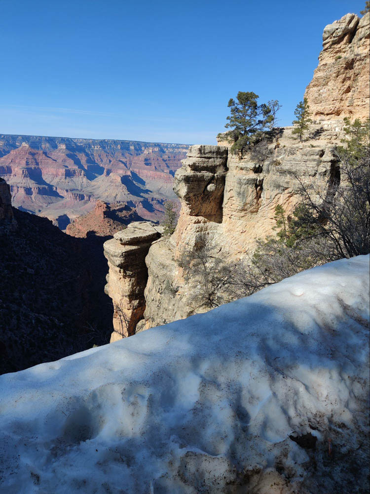
Не перестают завораживать масштабы и панорамные виды. Денис уже писал, что мы были там когда-то. Но, даже при повторной встрече,  каньон  не перестает поражать.

Удивило то, что даже не очень спортивные люди отваживаются на это рискованное мероприятие. Конечно, чаще на тропе встречаются хорошо подготовленные ребята, но вот, например, семидесятилетнюю старушку встретить я никак не ожидала. Встречались также дети младшего школьного возраста и мужики с пивным брюшком. Вероятно эти люди запланировали ночёвку на дне, но ведь дошли же. Так что, ребята, если спуск в Гранд каньон — мечта всей вашей жизни, не теряйте шанс.

Categories
Trips

Grand Canyon, or there and back.

I've wanted to reach the very bottom of the Grand Canyon for a long time. But the problem is that the campsites at the bottom of the canyon are very limited, and reserving them is very difficult. But there is another way: to descend and ascend in one day, without spending the night. People have written that it's difficult, but possible.

Almost ten years ago, when we first visited this park, we even walked a short distance down the trail. And I decided I absolutely had to make it to the very end.

So, when Natasha and I were planning our grand trip to the Southwest, we added the Canyon to it. I read the descriptions of the descent and picked a route.

This route has two very important advantages:

  1. We descend one route and ascend another, so we see the canyon from slightly different angles.
  2. On the way up, you can collect water at a point called Havasupai Gardens—about halfway up the trail and a third of the way up. This is important because it allows you to carry less water.

Everyone advised getting on the trail as early as possible to get back before dark. There's no parking at the trailhead, so the best option is to leave your car at the information center and take the free shuttle. The shuttles start running at 6:00 AM, so we decided to arrive around then.

So, we got up at five in the morning, made coffee, and headed out. It's about an hour to the canyon, the road is empty, and the entrance to the park is still free. The only people greeting us are deer.

Once in the park, we had a quick breakfast, found our bus (it runs every half hour at this time), and at about 7:40, we were at the trailhead. There were about fifteen people with us who had arrived on the same bus. But not everyone makes it all the way to the bottom—many turn around at one of the waypoints.

Along the trail, there are several signs with warnings in four languages: they suggest you reconsider whether you can make it up and down in one day. Thanks for the warning, we'll continue on. 

The descent was fairly easy. At one point, we had to stop and stuff extra clothes into our backpack: it had been +1°C when we set out, but now the sun was rising, and the lower we got, the warmer it would be. We stopped for a rest at one of the waypoints, drank some water, and then continued on.

About halfway down

The road winds steeply. In the lower third of the way, I start to feel my calf muscles tighten up (they'll be aching for the next two or three days), but for now, I can walk.

Here on this serpentine road - lower and lower...

Finally, the Colorado River came into view. Here it was a dirty brown (upstream it was green). A bridge spanned the river—we were headed that way. As we walked, I wondered how the necessary structures and materials for the bridge were delivered here. I decided it was by helicopter. Turns out that wasn't the case—there's a sign below explaining that the bridge is called "“Black Bridge” (“Black Bridge”), it was built in 1928, and everything necessary was delivered from above on mules and on the shoulders of the Indians of the local tribe Havasupai

Finally, we reached the bridge. Hooray! We took a selfie on the bridge. Now it's just minutes to the camp. There's civilization there (which we don't really need), but the most important thing is water—we need to refill our canteens.

A few minutes' rest, and then we're back on our way. We make a small detour to pass by a campsite—a cozy spot on the banks of a creek that flows into the Colorado. We cross the river again, this time a different way., Silver, the bridge, and we walk along a pleasant, gentle trail along the stream. But if we hadn't crossed, we would have climbed to the northern edge of the Canyon—and from there to our car. four hours drive, and it’s still unclear on what...

The road gradually becomes steeper and steeper, and here we come out into a small oasis called “Havasupai Gardens” (until November 2022, this place was called “Indian Gardens”, until it was renamed (At the request of the Havasupai tribe). It's nice there—a stream flows, lots of trees, and there's drinking water. It's about halfway up the canyon (about 4.5 miles from the bottom) and a third of the way up. There's another campsite there, and you also need to get a permit in advance for that. Logistically, I liked this campsite much better—you don't have to lug a backpack all the way down and, most importantly, up, and running from here to the bottom of the canyon isn't that difficult. Plus, the views up there are much better than at the bottom.

Havasupai Gardens - there's plenty of water and greenery here, but a steep climb awaits us.

We rest here and refill our water supplies—there won't be any further. Almost immediately, the steepest climb begins here—three miles of switchbacks. We move slowly—about a mile and a half an hour. Every hour we stop for about 10 minutes and drink half a liter of water between us. Within a minute, our mouths are dry again—the air here is very dry. We have a half-liter canteen and a soft plastic five-liter jerrycan. I poured about two liters into it so as not to lug around extra. We drink water from the canteen and refill it from the jerrycan. There's still water, but we need to conserve a little. Besides, there's snow on the slopes above, so if it gets really tight, we can stuff it into the canteen and melt it.

The climb is quite challenging, but manageable. It's far from the hardest hike I've done in the last few years—it's third or fourth on my list. The hardest was a six-mile section in the Adirondack Park two years ago, where we trudged up for three miles and then down—with no trail at all, along a stream bed and over huge rocks, and in the rain, to boot. Compared to that hike, this trail is a real treat…

At the top, the trail is covered in a layer of slightly melted ice and mud. It's a good thing we brought our poles; they came in very handy here. Earlier this morning, as we were leaving, I saw some people lugging crampons along. I shrugged in confusion at the time, but now I realize it makes sense. However, the poles are quite sufficient; the walking is fine.

 We started seeing sightseers descending from the top—they're easily identified by their casual clothing and footwear. It must be tough for them on this ice…

Finally, the steep switchbacks end, and now there's a relatively gentle climb for about half a mile. The end of the route is in sight…

The path we climbed is visible on the right side of the photo.

Here we are at the top! We take a photo at the sign indicating the start/end of the trail and pour the last of our water into our flasks. There's just one flask left—our timing was spot on. 🙂

Now we just need to catch the bus we need and get to the car. The route is complete!

Categories
Trips

Grand Canyon - we did it!

Yesterday, Natasha and I walked from the South Rim of the Grand Canyon down to the Colorado River and back, all in one day. About 27 km, 44,000 steps, and a mile and a half of elevation gain. The entire journey took nine hours.
It wasn't easy, but we've been on more difficult routes recently.